
Melissa Forecast To Rapidly Intensify This Weekend
Tropical Storm Melissa is likely to rapidly intensify into a major hurricane. But its forecast sluggish movement may produce life-threatening floods and landslides and days of tropical storm or hurricane conditions for parts of Jamaica, Haiti and Cuba.
(MORE MAPS: Melissa Map Tracker)
Where It Is Now
Melissa’s is located in the central Caribbean Sea, around 215 miles southeast of Jamaica. And it isn’t moving much, at the moment.
Some outer bands of showers and thundershowers are streaming northward across parts of Jamaica, Hispaniola and Puerto Rico with soaking rainfall and gusty winds.

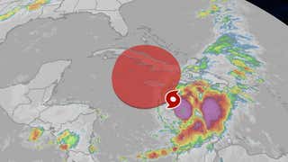
Current Satellite Image
(The highest cloud tops, corresponding to the most vigorous convection, are shown in the dark red and pink colors. Clustering, deep convection around the center is a sign of a healthy tropical system.
)
Forecast
Where It May Go
Melissa should begin a westward drift by this weekend that could bring it very close to or over Jamaica for several days from this weekend through at least Tuesday. Whether landfall occurs or not, means little to the forecast for impacts. Extreme rainfall is expected.
After that, Melissa should pick up forward speed and turn northeastward toward eastern Cuba by Wednesday or Thursday, then swipe through parts of the Bahamas before heading into the western Atlantic Ocean late next week, where it could eventually become a threat to Bermuda.
For now, Melissa is not a threat to South Florida, but we will continue to monitor the forecast closely.
How Strong?
Wind shear that has kept Melissa from organizing and gaining strength is expected to relax a bit by this weekend. Warm, deep Caribbean Sea water will serve as fuel to allow Melissa to become a Category 4 this weekend or early next week.
However, if Melissa’s center is too close to Jamaica, that could hold its intensification in check a bit.
The current intensity forecast for Melissa is denoted by the Saffir-Simpson Hurricane Wind Scale categories in the forecast path graphic below.
(MORE: Rapid Intensification Is More Common Than You Think)

Current Status, Forecast Path
(The red-shaded area denotes the potential path of the center of the tropical cyclone. It’s important to note that impacts (particularly heavy rain, high surf, coastal flooding, winds) with any tropical cyclone usually spread beyond its forecast path.
)
Rainfall Flood Danger
A particularly dangerous situation is unfolding for parts of the Caribbean, as the center of Melissa is expected to linger for several days. Slow-moving tropical storms and hurricanes have the potential to wring out prolific rainfall totals.
Parts of Haiti and Jamaica could pick up up to 20 inches of additional rainfall through next week. Local amounts, especially over mountainous terrain, could be higher.
That heavy rainfall is likely to trigger life-threatening flash flooding and landslides in hilly and mountainous terrain. The National Hurricane Center warned that “extensive damage to roads and buildings is expected” in southwestern Haiti “potentially isolating communities for an extended period of time.”
Some bands or clusters of locally heavy rain are also likely in the Dominican Republic, Puerto Rico, the Virgin Islands, the Turks and Caicos, Cuba and parts of the Bahamas, which could also trigger local flash flooding.
(MORE: Why Slow-Moving Storms Are The Worst)
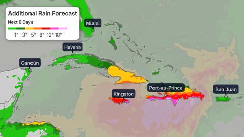
Additional Rain Forecast
(This should be interpreted as a broad forecast of where the heaviest rain may fall and may shift based on the forecast path of the tropical cyclone. Higher amounts may occur where bands of rain stall over a period of a few hours. )
Wind Alerts
The map below shows the latest watches and warnings in effect for Melissa.
A hurricane watch means hurricane-force winds are possible, and tropical-storm-force winds could move in within 48 hours.
A tropical storm warning means tropical storm conditions are expected within the next 36 hours. These winds could persist for days once they start.
These alerts currently cover parts of southern Haiti and Jamaica.

Watches And Warnings
(A watch is issued when tropical storm or hurricane conditions are possible within 48 hours. A warning is issued when those conditions are expected within 36 hours.
)
Wind Threat
According to the National Hurricane Center, hurricane conditions are possible in Haiti beginning Saturday, and either late Saturday or Sunday in Jamaica.
Tropical storm conditions are expected to move into Haiti later Friday and into Jamaica Saturday.
(MORE: Not Too Late In Season For An Intense Hurricane)

Hurricane Wind Chances
(The contours above show the chance of hurricane-force winds (at least 74 mph), according to the latest forecast by the National Hurricane Center.
)
Number 13
Tropical Storm Melissa formed late Tuesday morning, the 13th storm of the 2025 Atlantic hurricane season.
That’s roughly on par with the average date of the 13th storm from 1991 through 2020 (Oct. 25), according to the National Hurricane Center. It’s also one storm shy of the average number of storms for an entire season, 14.
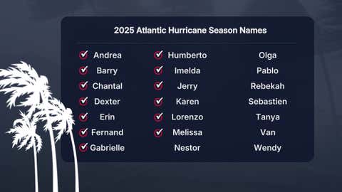
The 2025 Atlantic hurricane season names list. Those storm names used up already have check marks next to them.
Melissa is also the first storm of the season to track into the Caribbean Sea. As you can see in the season-to-date tracks map below, most other storms and hurricanes have curled north of the Caribbean Sea this season.
That’s due either to steering winds in the Atlantic, or hostile conditions for development in the Caribbean Sea prior to Melissa.

2025 Atlantic Hurricane Season Tracks To Date
Check back with us at weather.com for the latest forecast updates on Melissa, and elsewhere in the tropics.
Jonathan Erdman is a senior meteorologist at weather.com and has been covering national and international weather since 1996. Extreme and bizarre weather are his favorite topics. Reach out to him on Bluesky, X (formerly Twitter) and Facebook.