AccuWeather.com
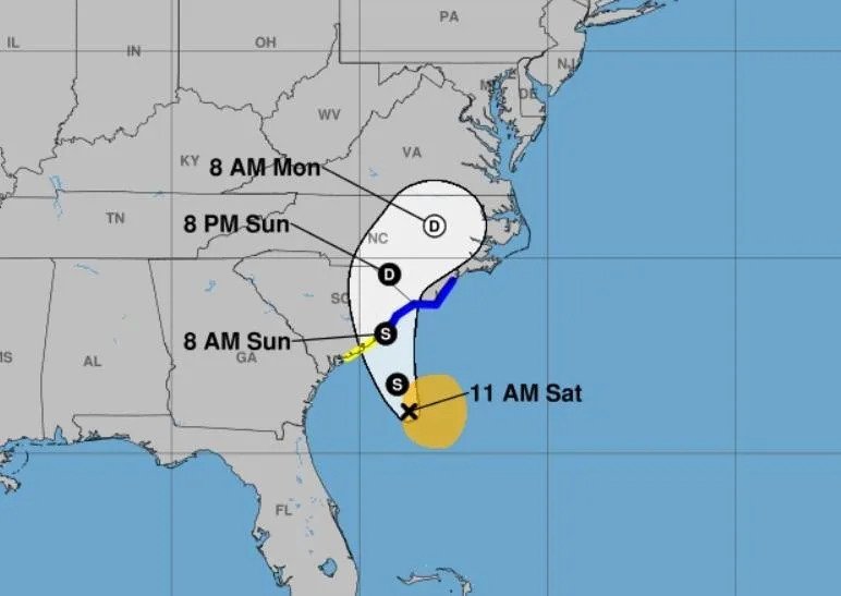
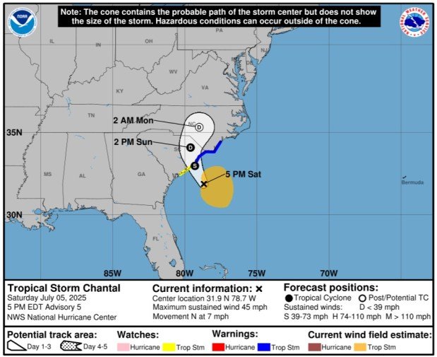
After AccuWeather proactively declared the tropical system off the Southeast coast a tropical rainstorm on Friday morning to raise public awareness, it strengthened and became Tropical Depression 3 on Friday afternoon. The tropical depression then gained further wind intensity and became Tropical Storm Chantal on Saturday morning. With limited time over water and some dry air and wind shear nearby, limited additional strengthening is expected. However, there will be notable impacts through the remainder of the holiday weekend.
“This was a classic example of homegrown development, by which a tropical storm formed close to the southeast Atlantic coast and in an area where it is typical for July,” said AccuWeather Lead Hurricane Expert Alex DaSilva.
Chantal is the third tropical storm of the 2025 Atlantic hurricane season, following Andrea and Barry from June.
The most widespread impact will be rain, which will fall from Florida all the way to the Delmarva Peninsula. A broad zone of 1-2 inches of rain is expected. Closest to where the center makes landfall, 2-4 inches of rain will soak an area from the Outer Banks of North Carolina to northern coastal South Carolina. A small area of 4-8 inches will fall between Wilmington, North Carolina and Myrtle Beach, South Carolina.
“The heavy rainfall can lead to flooding, especially in low-lying and poor drainage areas,” cautioned AccuWeather Senior Meteorologist Tyler Roys.

AccuWeather.com
With a persistent onshore flow around the circulation of Chantal, there will be coastal hazards as well. Even far away from the track of the storm, rough surf, rip currents and beach erosion are possible. In areas from Savannah to Jacksonville, those hazards will gradually subside later in the weekend as the storm moves northward.

AccuWeather.com
That same persistent onshore flow will also raise water levels as Chantal gets closer to landfall. Although the storm will not have a lot of wind intensity, there will be enough to raise the concern of storm surge along the coast of North and South Carolina.

AccuWeather.com
The majority of the wind with Chantal will remain offshore. However, coastal areas of South Carolina and southern North Carolina will have wind gusts of 40- to 50-mph wind gusts with an AccuWeather Local StormMax™ of 60 mph.
Have the app? Unlock AccuWeather Alerts™ with Premium+
“The strongest winds are expected near and to the east of where the storm makes landfall and can produce tree damage, localized power outages and some structural damage,” warned Roys.

AccuWeather.com
Besides rain, wind and coastal hazards, there will be a risk of isolated tornadoes. This is common with tropical systems, since there is already spin associated with it. They are usually less intense and shorter-lived than they are in other cases, but they can still cause enhanced damage on a localized level.

AccuWeather.com
Even after Chantal moves farther inland and loses wind intensity, there will still be clouds and downpours that can move northward along the mid-Atlantic coast. This could limit heat the eastern extent of heat that will be building from the Appalachians westward.
“Elsewhere in the tropical Atlantic, there is a vast area of dry air, wind shear and Saharan dust that will limit or prevent tropical development in the short term, and that is not unusual for July,” explained DaSilva.

AccuWeather.com
Conversely, the eastern Pacific has been very active. AccuWeather meteorologists are watching for more development in the coming days. Luckily, no land impacts are expected.

AccuWeather.com
The next name on the list for the 2025 eastern Pacific season is Gil.
Want next-level safety, ad-free? Unlock advanced, hyperlocal severe weather alerts when you subscribe to Premium+ on the AccuWeather app. AccuWeather Alerts™ are prompted by our expert meteorologists who monitor and analyze dangerous weather risks 24/7 to keep you and your family safer.