July 5 (UPI) — Tropical Storm Chantal formed in the Atlantic on Saturday morning and is projected to reach South Carolina’s coast on Sunday, the National Hurricane Center said.
South and North Carolina are already encountering dangerous rip and surf conditions during the Fourth of July holiday weekend
Chantal, the third named storm of the season, will be the first system to impact the United States this Atlantic hurricane season, which began June 1.
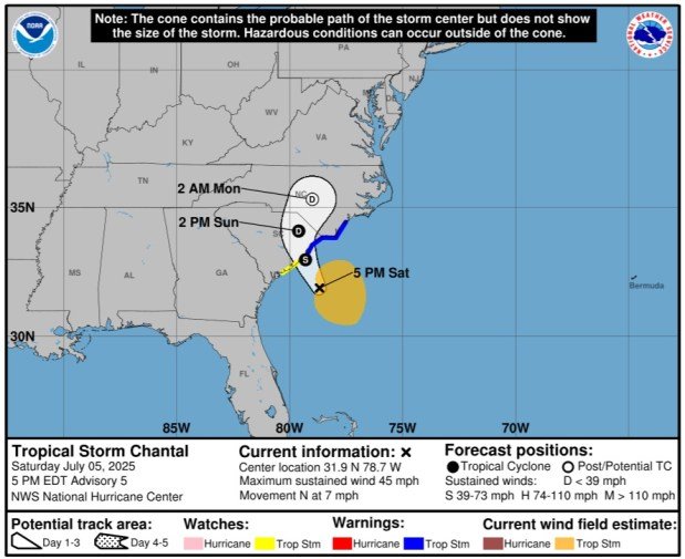
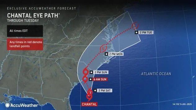
Landfall is predicted between Charleston and Myrtle Beach in South Carolina at 8 a.m. Sunday and will become a depression upon going inland in North Carolina on Sunday night, NHV said.
“As tropical cyclones go, this storm will be relatively minor and short-lived,” Frank Strait, severe weather liaison with the South Carolina State Climate Office, told the Island Packet.

Chantal is forecast to hit the Carolinas on Sunday as a tropical storm. Image by National Hurricane Center
In the 5 p.m. EDT update, Chantal had maximum sustained winds of 45 mph and was traveling northward at 7 mph. In the 11 a.m. update, the winds were 40 mph.
The storm became a tropical depression Friday night off the coasts of Northeast Florida and Georgia.
Chantal was about 95 miles south-southeast of Charleston, S.C., and about 165 miles south-southwest of Wilmington, N.C.
A tropical storm warning is in effect for the South Santee River, S.C., to Surf City, N.C. A tropical storm watch goes from Edisto Beach to South Santee River.
Tropical-storm-force winds extend outward up to 140 miles east of the center.
“Chantal has barely moved since last night, but a motion to the north-northwest is expected to begin soon,” NHC forecasters said. “The main steering features appear to be a mid- to upper-level low over the Gulf and a narrow mid-level ridge across the mid-Atlantic region.”
Some strengthening is expected before Chantal reaches the coast, NHC said.
A turn to the northeast is forecast by Sunday night, NHC said. On the forecast track, the center of Chantal is expected to move across South Carolina’s coast Sunday morning.
Chantal is expected to produce heavy rainfall in the Carolinas through Monday with 2 to 4 inches and local amounts of 6 inches. NHC said these rains could cause flash flooding
“The combination of storm surge and tide will cause normally dry areas near the coast to be flooded by rising waters moving inland from the shoreline,” NHC said.
Storm surge is forecast at 1-3 feet from South Santee River to Surf City and 1-2 feet from Edisto Beach to South Santee River.
Also, isolated tornadoes are possible Saturday night into Sunday along South Carolina’s eastern coast and much of North Carolina, NHC said.
“This was a classic example of homegrown development, by which a tropical storm formed close to the southeast Atlantic coast and in an area where it is typical for July,” AccuWeather Lead Hurricane Expert Alex DaSilva said.
In Wilmington, N.C., red flags were up at the beach.
“The rip current advisory is going to be high for today and potentially tomorrow as well. If you see red flags, under no circumstances should you get into the water,” Sam Proffitt, the Ocean Rescue Director at Wrightsville Beach, told WRAL-TV.
“Although it might look calm out there and we don’t have 8-foot swells coming in, rip currents can occur at any time, anywhere along the beach.”
There were 192 rip current drownings reported from 2000 to 2024 in North and South Carolina.
“For most swimmers, the only thing that they notice is that they are unable to make it back to shore. They start swimming into shore and they notice that they are moving backwards, and that’s typically where the panicking process starts, and the whole drowning process then begins,” Proffitt said.
Officials are also warning beachgoers about possible lightning in the area.
In the Charleston area, WCIV-TV meteorologist Sonya Stevens said there is high surf and high rip current risk Saturday and water activities are discouraged, including boating.
Andrea and Barry, the first two named systems of the Atlantic hurricane season, have dissipated.