Ragasa picks up strength over the South China Seapublished at 10:08 BST
 Sarah Keith-Lucas
Lead weather presenter, BBC Weather
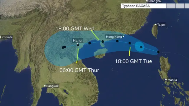
The expected track of the storm is
in a westerly direction, and has edged further north than previously forecast.
The worst impacts to Hong Kong
will be felt during Tuesday night and early Wednesday local time.
Although the eye of the storm won’t make direct landfall here, it will
pass close to the south as a ‘very strong typhoon’. There will be a
significant storm surge of around 2m around the Pearl River Estuary and up to 4
to 5m close to Tolo Harbour, as well as waves of nearly 14m at sea.
By Wednesday evening, Landfall is
expected on the south China coast, likely near Zhanjiang in Guangdong. Ragasa
should weaken a little before landfall due to increased friction as it
approaches land, but will still be a ‘Very strong typhoon’ with sustained winds
of 155km/hr and gusts up to 220km/hr,.
Torrential rain is expected today
in Taiwan, southern Fujian and eastern Guangdong, spreading across Guangdong,
Hong Kong and into Hainan. Some areas could see 250-450mm of rain.