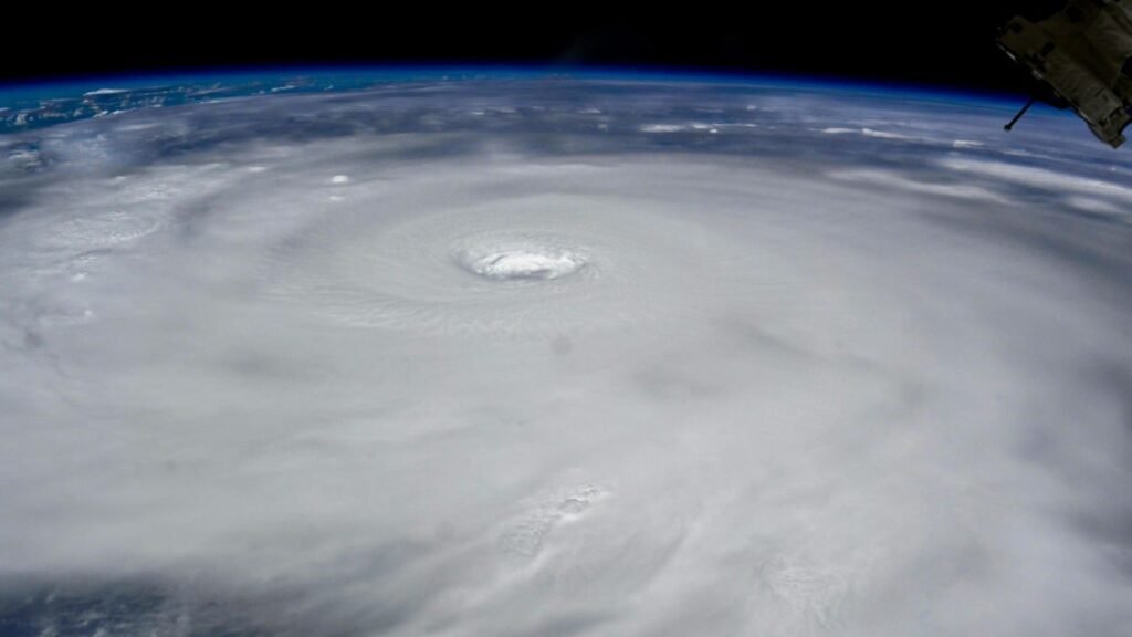
After weeks of weird peak-season sluggishness, the Northern Hemisphere tropics were buzzing with activity on September 22, the autumnal equinox. In the Atlantic, Hurricane Gabrielle was arcing just southeast of Bermuda at Category 3 strength, while two other systems bore watching in the tropical Atlantic.
The most immediate threat to a high-population area was in the Northwest Pacific, where Super Typhoon Ragasa became the first Category 5 typhoon of 2025 as it raked the far northern Philippines on Monday local time. (Ragasa is being called Nando in the Philippines, which maintains its own naming lists for tropical cyclones.) Ragasa is the planet’s third Category 5 storm of 2025, joining Hurricane Erin in the Atlantic (August 16) and Cyclone Errol off the coast of northwest Australia (April 16). The 1990-2024 average globally for an entire year is 5.3 Cat 5s; there were five in 2024.
Ragasa underwent an eyewall replacement cycle just before passing over the tiny, sparsely populated Babuyan Islands of the northernmost Philippines. After Ragasa’s powerful northern eyewall churned over Babuyan Claro Island (about 2,000 residents), the newly enlarged eye passed directly over Calayan Island (the most populous of the group, with about 10,000 residents). More than 8,200 people took shelter in Calayan, and there were no immediate reports of injuries across the islands, according to the Associated Press.
A drifting buoy along the path of Ragasa’s eye recorded a sea-level air pressure of 900.3 millibars (hPa) at around 3Z Monday (11 p.m. Sunday EDT). Since surface winds were measured at 35 knots (40 mph), the actual lowest pressure within Ragasa was likely closer to 897 mb, according to Jasper Deng, who manages the tropical weather pages for Wikipedia. This is likely the lowest directly-measured pressure in any Northwest Pacific storm since an 883-mb reading from Super Typhoon Meranti in 2016.
As of midday Monday, there was still crucial meteorological and geographical uncertainty in how Ragasa would affect far southern China. After slight weakening, Ragasa was a Category 4 typhoon with top sustained winds of 150 mph (240 km/h) at 8 a.m. EDT Monday, according to the Joint Typhoon Warning Center. The typhoon has moved steadily west-northwest and will gradually bend west by midweek, but since its track on Tuesday and Wednesday local time will closely parallel the coast from Hong Kong westward, only a slight angle left or right could either keep the core of Ragasa well offshore or bring it dangerously close to the coast.


It’s also uncertain how much Ragasa might weaken or not by the time it makes landfall, which is expected to occur on Wednesday night local time west of Hong Kong and near or just east of the Leizhou Peninsula. As of Monday morning EDT, the Joint Typhoon Warning Center was predicting Ragasa would gradually weaken, making landfall at Category 1 strength with top sustained winds of around 75 knots (85 mph or 137 km/h). However, both the HWRF and HAFS-A intensity models depict landfall at Cat 3 strength. The metro area of Zhanjiang (population 7 million), near the top of the Leizhou Peninsula, is among those cities where direct impacts from Ragasa appear most likely.
Should Ragasa angle northward, Hong Kong could experience sustained winds into the tropical-storm-force range. Flights at Hong Kong International Airport have been canceled from Monday night into Wednesday local time, Bloomberg reported.
#Gabrielle has rapidly intensified during the night, clearing out an eye and becoming a major hurricane. Very nice outflow on the western side, showing the jet interaction beginning! This will help it keep intensifying before shear gets too high and the interaction becomes unfavorable
— Alex Boreham (@cyclonicwx.bsky.social) 2025-09-22T14:04:31.472Z
Gabrielle powers up safely away from land, but the Azores could see impacts by late week
The Atlantic’s second hurricane of the year finally arrived on Sunday, September 21, when Tropical Storm Gabrielle embarked on a furious round of rapid strengthening well southeast of Bermuda in the open North Atlantic. At 11 a.m. EDT Monday, Category 3 Gabrielle was positioned about 180 miles southeast of Bermuda, packing top sustained winds of 120 mph (195 kp/h) and heading north at 10 mph (17 km/h).
Gabrielle’s attainment of hurricane status comes well past the 1991-2020 average formation date of the season’s second hurricane, August 26. On average, by September 22, the Atlantic has seen 4.5 hurricanes and 2.1 major hurricanes, according to statistics maintained by Colorado State University. Gabrielle also marks the latest appearance of a year’s second Atlantic hurricane since 1994, when Florence reached hurricane strength on November 4.
From 11 a.m. EDT Sunday to 9 a.m. Monday, Gabrielle vaulted from tropical-storm strength (peak winds of 65 mph) to major-hurricane strength (peak winds of 120 mph) in a mere 22 hours, far outpacing the threshold for rapid intensification of 30 mph in 24 hours. Gabrielle is taking advantage of strikingly warm surface water in the subtropics and midlatitudes, especially from around 30 to 40 degrees north, that now extends across most of the Northwest Atlantic as well as the North Pacific (see embedded skeet below).


Much like the year’s first major Atlantic hurricane, Category 5 Erin, Gabrielle is following a near-perfect recurvature track that’s minimizing impacts on North and Central America and the Caribbean. After a sharp right turn from Sunday into Monday, Gabrielle will accelerate east-northeast across the remote North Atlantic for several days. Wind shear will gradually increase through the period, but the unusually warm sea surface temperatures should allow Gabrielle to remain a major hurricane through Tuesday, perhaps even bumping up briefly to Category 4 strength as predicted by the National Hurricane Center.
Outflow at the jet-stream level from a strong upper-level trough passing north of Gabrielle may help keep Gabrielle near hurricane strength as it approaches the northwest Azores around Thursday night. Winds of at least tropical storm strength appear likely to reach that part of the island chain, whether or not Gabrielle has become a post-tropical cyclone by then.
If Gabrielle does affect the Azores toward the end of its life, it would be a fitting — if bizarre — bookend to Hurricane Erin, which affected a different part of the far eastern Atlantic at the beginning of its life. Although Erin ended up reaching Cat 5 strength, the worst impacts occurred from the disturbance that gave birth to Erin as it passed over the Cabo Verde Islands on August 10-11. Torrential flooding displaced 1,500 people and led to at least 12 deaths, the Red Cross Red Crescent reported.


Two new Atlantic systems to watch
Along with Gabrielle, the National Hurricane Center is keeping its eyes on two disturbances, both moving westward through the the Main Development Region between the Caribbean and Africa. Both of these remained disorganized on Monday, with showers and thunderstorms (convection) yet to congeal around any defined surface center. The ultimate fate of these systems is highly uncertain, depending in part on how they interact with each other.
The easternmost of the two waves appears most likely to follow in the watery footsteps of Gabrielle, likely heading northwest into the weakness in the upper flow left by Gabrielle and eventually recurving in similar fashion. The 8 a.m. EDT Tropical Weather Outlook from the National Hurricane Center set the two- and seven-day odds of this eastern wave developing into at least a tropical depression at 30% and 80%, respectively.
As the westernmost wave moves quickly west-northwest at around 15-20 mph (24-32 km/h), it will bring patches of squally weather and a chance of localized flash flooding to the northern Leeward Islands on Tuesday, perhaps extending into the U.S. Virgin Islands and parts of Puerto Rico by Wednesday. The long-term future of this system hinges largely on the evolution of a large upper-level storm that will bring an early-autumn cooldown to parts of the eastern U.S. later this week. The operational GFS model, along with some ensemble model members, suggests that part of this upper low could break off and slide toward the Gulf Coast; in turn, that could allow the western disturbance in the Atlantic to circulate around it rather than recurving out to sea.
There is huge uncertainty in how these features will play out, including whether the western wave develops at all, so we’ll likely be in wait-and-see mode for several more days. The 2 p.m. EDT Tropical Weather Outlook from the National Hurricane Center gave the western disturbance two- and seven-day odds of development of 10% and 50%, respectively.
Republish our articles for free, online or in print, under a Creative Commons license.


