SAN JUAN COUNTY, Utah (ABC4) — Two tornadoes touched down in southeastern Utah’s San Juan County early Saturday afternoon.
The National Weather Service (NWS) in Grand Junction, Colo., issued two Tornado Warnings that included parts of Utah. The NWS issued the first warning at 12:46 p.m. MDT, which included the area of southeastern San Juan County.
A confirmed tornado was located seven miles northeast of Montezuma Creek, or 22 miles southeast of Blanding, Utah. This tornadic thunderstorm spanned over rural areas of San Juan County, including Hovenweep National Monument, and was confirmed by law enforcement in the area.
The warning was extended until after 2 p.m. as the tornado tracked northeast into Colorado. Photos shared by ABC4 viewer Allyen Allen show the storm passing tracking through non populated areas of San Juan County. Emergency management indicated hail an inch in diameter was also observed.
-
Tornado in San Juan County (Courtesy of Allyn Allen)
-
Tornado in San Juan County (Courtesy of Allyn Allen)
“Flying debris will be dangerous to those caught without shelter,” the NWS stated. “Mobile homes will be damaged or destroyed. Damage to roofs, windows, and vehicles will occur. Tree damage is likely.”
A second tornado touched down in the northeastern portion of San Juan County shortly after the first, at 1:41 p.m. This tornado was radar-indicated and occurred about 16 miles east of Monticello, Utah. This tornado was closer to the Utah/Colorado state line and moved into southwest Colorado shortly after 2 p.m.
Both of these tornados formed in Utah, touched the ground, and tracked northeast across the state line into Colorado. These storms occurred as a large, slow-moving upper level low lifted northeast over Utah and Wyoming Saturday morning. The Four Corners region has been moisture-rich the last few days, with plenty of wind shear present and clearing skies Saturday afternoon, which increased CAPE, or “convective available potential energy.” Higher CAPE values indicate greater instability and a higher likelihood of severe storms with heavy rain, damaging wind, and large hail.


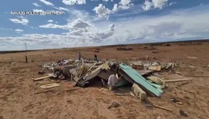
Tornado in southern Utah (Courtesy of Navajo Nation Police)
Utah averages about two tornadoes a year, and we typically see them in rural areas. These two tornadoes would be our second and third tornadoes of 2025. You may remember, on July 12, a fire-induced tornado developed within the Deer Creek wildfire near La Sal, Utah. The fire-nado was on the ground for approximately 12 minutes and didn’t move much — it was almost stationary. Dwellings and outbuildings in the area sustained a mix of fire and wind damage. Wind damage sustained by the remaining structures not burned by fires resulted in the tornado being given an EF-2 rating. Residents were evacuated prior to the tornado and no injuries were sustained by fire personnel.
We will wait for a full report on these tornadoes in southeastern Utah and for your latest forecast, stay with our 4Warn Weather forecast both on-air and online, and now streaming on News4Utah+.
Latest headlines:
Copyright 2025 Nexstar Media, Inc. All rights reserved. This material may not be published, broadcast, rewritten, or redistributed.
For the latest news, weather, sports, and streaming video, head to ABC4 Utah.


