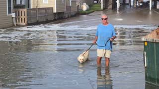
Outer Banks Locals Wade Through Erin Storm Surge
Simply put, today is the day that Hurricane Erin will do its worst along the U.S. East Coast. We’re already see the large waves and coastal flooding in North Carolina’s Outer Banks, but this large storm’s trek northeast is also pushing ocean swells high onto beaches along New York’s Fire Island and the Jersey Shore.
Our meteorologists have a full rundown of where Erin is now, where it’s headed today and when you can expect the peak of today’s impacts.
Our team will also keep you updated throughout the day on where the flooding is happening and the closures that result.
(10:49 a.m. EDT) Virginia Beach Surfing Competition Suspended
Surfers from dozens of countries won’t be getting in the waters off Virginia Beach to compete today. The annual East Coast Surfing Championships called off today’s heats because of Hurricane Erin.
This video from the First Street Jetty shows why organizers want everyone to stay out of the water.
Crews took down the competition setup along the beach yesterday, with plans to rebuild it on Friday and get back to the competition.
(10:26 a.m. EDT) Massive Hurricane Erin As Seen From Space
From digital meteorologist Caitlin Kaiser:
NOAA’s GOES East Satellite captured a striking view of Erin from above as it began to pull away from the East Coast this morning. The hurricane is expected to speed up while taking a northeastward curve today. Though the storm is forecast to gradually weaken, it will bring dangerous high surf and life-threatening rip currents to the East Coast through the weekend.
(10:00 a.m. EDT) Morning Update On Closures Along NC-12
North Carolina transportation officials say multiple sections of this crucial highway in and out of the Outer Banks are closed this morning. They shared this update in a Facebook post:
Current road conditions:
Kitty Hawk – No issues, minor blown sand, roadway is passable.
Pea Island – Some overnight overwash and deep blown sand on roadway. Section closed.
Buxton North End – Overwash occurred most of last night and during this morning’s tide. Sand and standing water on roadway. Section closed.
Hatteras – Major overwash with dune breaches at yesterday high tide. Deep sand, water, and debris covering the roadway. Section closed.
Ocracoke – Major overwash. Large sections of the protective dune are flat. Section is closed.
Rodanthe – Significant overwash on several secondary sections.
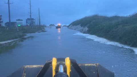
This image shows a flooded section of Highway 12 in North Carolina’s Outer Banks on Thursday, August 21, 2025.
(NCDOT NC 12 via Facebook)
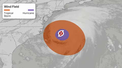
(09:39 a.m. EDT) How Close Was Erin?
From senior meteorologist Jonathan Erdman:
It turned out, Erin’s center came as close as 200 miles east-southeast of Hatteras, North Carolina, as of 2 a.m. ET today.
But given Erin’s tropical storm force winds were up to 480 miles wide, it is bringing tropical storm conditions to coastal North Carolina and the Virginia Tidewater today, not to mention coastal flooding, high surf and rip currents along the East Coast.
A hurricane — especially one this large — doesn’t have to make landfall to be impactful.
(09:20 a.m. EDT) Massive Swells At Popular Florida Pier
A Florida meteorologist shared some impressive sunrise video of huge ocean swells crashing onto Juno Beach. The waves popped out a few boards of the Juno Pier, which remains open right now.
(09:00 a.m. EDT) Another High Tide
From senior meteorologist Jonathan Erdman:
We’re at another high tide along the East Coast and, as you can see in the graphic from the National Weather Service below, there are three more high tides after this morning where coastal flooding is expected in the northern Outer Banks of North Carolina.
This evening’s high tide is the one where flooding may be greatest from North Carolina to the Jersey shore, as northeast winds from soon departing Hurricane Erin keep pushing water to the coast.
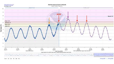
Current water levels and forecast for Duck, North Carolina, as of Thursday morning.
(NOAA/NWS)
(08:44 a.m. EDT) Will NC-12 Hold?
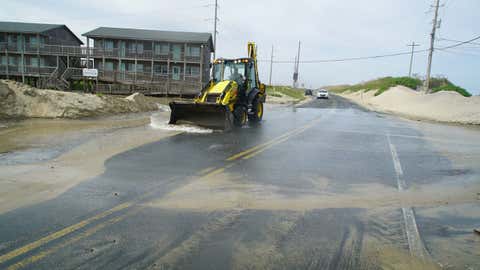
A front-end loader pushes seawater from Hurricane Erin down NC-12 in Buxton, North Carolina, on Wednesday, Aug. 20, 2025.
(AP Photo/Allen G. Breed)
From managing editor Sean Breslin:
That’s the million-dollar question along North Carolina’s Outer Banks. The highway known as NC-12 is a lifeline for locals, vacationers and emergency responders alike. It spans about 150 miles, connecting the islands of the Outer Banks, but stretches of it have been destroyed by hurricanes of previous years.
Last night, about a 48-mile stretch of the highway was closed due to storm surge between Oregon Inlet and Hatteras Village.
(08:40 a.m. EDT) Welcome To Day 11 Of Erin
From senior meteorologist Jonathan Erdman:
This “Cabo Verde” storm already made quite a voyage. It’s 2,941 miles away from where it first became a tropical storm 10 days ago near Cabo Verde.
(08:16 a.m. EDT) Sun Rises On East Coast
From senior writer Chris DeWeese:
Early risers along the East Coast are posting photos to social media of a pretty spectacular sunrise, courtesy of Hurricane Erin’s moisture. This photo from Charleston, South Carolina, was just posted by meteorologist Joey Sovine.
(07:47 a.m. EDT) Imagine Being On This Ferry
From managing editor Sean Breslin:
Keeping in mind that this is all the way up near the Rhode Island coast, check out how this boat was jostled by large waves yesterday evening:
(07:34 a.m. EDT) Buoy Shows 44.9 Foot Wave Height From Hurricane Erin
From senior writer Chris DeWeese:
Hurricane Erin is a huge storm capable of producing some giant waves. Many of these waves will remain unknown and unrecorded, but there are plenty of buoys out in the Atlantic capable of picking up data to give us some sense of what’s going on out there.
Keep an eye on buoy 41001, located 150 nautical miles east of Cape Hatteras, which recently reported significant wave heights of 44.9 feet. As senior digital meteorologist Jonathan Erdman explains, since “max wave heights” are usually 2x the sig. wave heights….there could be up to 90-foot waves well offshore!”